
SuDS Decision Support Tool for Small Scale Development

The category selected should most accurately reflect the proposed development on site.
The property can be considered as either Residential (properties used as dwellings such as housing) and Non-residential (properties used for industrial, commercial, agricultural, infrastructure, schools, community centres such as village halls, doctors, churches and leisure centres). Using these definitions of Residential and Non-residential property, there are nine categories based upon the type of development planned on site, which are;
If nothing else is proposed 'New impermeable ground areas' should be selected.
The type of development surface affects the water quality requirements of the proposed SuDS solution. The category selected should most accurately reflect the proposed development. There are three categories for residential and five categories for non-residential developments based upon increasing risk of pollution of the surface water runoff.
Residential Developments
Non-Residential Developments
The following surfaces should always be considered to be impermeable:
For permeable hard surfaces at ground level evidence will be required to show they are permeable (e.g. porous asphalt)
Total impermeable area of the whole site once development has been implemented.
The following surfaces should always be considered to be impermeable:
For permeable hard surfaces at ground level evidence will be required to show they are permeable (e.g. permeable block paving or porous asphalt)
Postcode is mandatory. It can be entered either by selecting the 'Get Postcode' button once a grid reference is entered. Alternatively the postcode can be entered manually.
Total impermeable area of the whole site once development has been implemented.
The following surfaces should always be considered to be impermeable:
For permeable hard surfaces at ground level evidence will be required to show they are permeable (e.g. permeable block paving or porous asphalt)
Total impermeable area of the whole site once development has been implemented.
The following surfaces should always be considered to be impermeable:
For permeable hard surfaces at ground level evidence will be required to show they are permeable (e.g. permeable block paving or porous asphalt)
The Brownfield runoff rate represents the total runoff from the site assuming the site is 100% impermeable.
An optional percentage improvement to the post-development runoff rate from the site.
Achieved by providing an additional volume of storage at the site, which reduces the rate of runoff to less than the pre-development conditions
The grid reference should be entered in Ordnance Survey National Grid format as eastings and northings.
e.g. for County Hall in Lewes the grid reference is
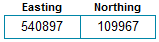
Include leading zeros if applicable
The Environment Agency flood map allows consideration of the interaction of surface water flooding and flow paths in relation to the site.
The SuDS Tool does not consider flood risk to the site. Additional assessments should be carried out to assess the risk of flooding to the proposed development site and if appropriate, a site specific flood risk assessment should be provided.